Displaying 1 - 20 of 24
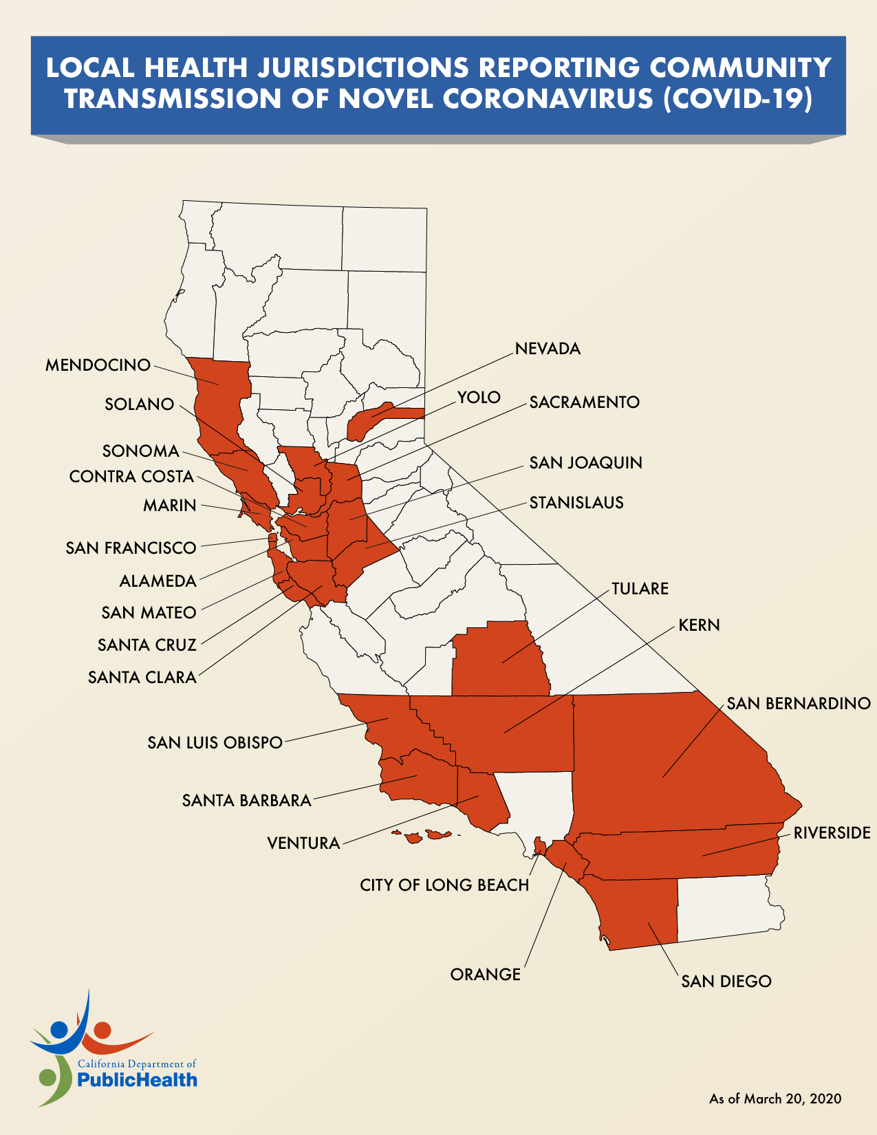
Local Health Jurisdictions Reporting Community Transmission COVID-19
Updated:
| Attachment | Size |
|---|---|
| COVID-19 California Community Transmission Map 3.20.20 (220.59 KB) | 220.59 KB |
Special District Maps
Updated:
| Attachment | Size |
|---|---|
| Rice Pest Abatement District #1 Maps (8.65 MB) | 8.65 MB |
Glenn County Road & Bridges Project Map 2017
Updated:
| Attachment | Size |
|---|---|
| Glenn County Road & Bridges Project Map 2017 (282.57 KB) | 282.57 KB |
Capay's Harvest
Updated:
| Attachment | Size |
|---|---|
| 10-16-23 (307.62 KB) | 307.62 KB |
| 4-18-23 (177.66 KB) | 177.66 KB |
| 4-3-23 (158.1 KB) | 158.1 KB |
| 12-16-22 (833.02 KB) | 833.02 KB |
| 7-18-22 (260.48 KB) | 260.48 KB |
| 4-13-22 (391.39 KB) | 391.39 KB |
| 11-6-19 (664.01 KB) | 664.01 KB |
| 3-15-19 (585.87 KB) | 585.87 KB |
| 3-1-19 (1.06 MB) | 1.06 MB |
| 12-14-17 (649.91 KB) | 649.91 KB |
| 5-5-17 (551.82 KB) | 551.82 KB |
| 4-28-17 (969.29 KB) | 969.29 KB |
| 8-5-16 (616.11 KB) | 616.11 KB |
| 2-26-16 (1010.01 KB) | 1010.01 KB |
| 3-17-15 (620.67 KB) | 620.67 KB |
| 8-27-14 (661.51 KB) | 661.51 KB |
| 6-17-14 (584.44 KB) | 584.44 KB |
Capay Elementary School
Updated:
| Attachment | Size |
|---|---|
| 11-13-23 (169.98 KB) | 169.98 KB |
| 5-8-23 (176.73 KB) | 176.73 KB |
| 9-9-22 (166.31 KB) | 166.31 KB |
| 4-14-22 (151.33 KB) | 151.33 KB |
| 10-25-19 (632.44 KB) | 632.44 KB |
| 5-10-19 (601.23 KB) | 601.23 KB |
| 12-18-18 (569.17 KB) | 569.17 KB |
| 5-25-18 (577.4 KB) | 577.4 KB |
| 12-1-17 (573.67 KB) | 573.67 KB |
| 3-10-17 (592.58 KB) | 592.58 KB |
| 10-28-16 (611.48 KB) | 611.48 KB |
| 9-30-15 (566.65 KB) | 566.65 KB |
| 8-25-15 (599.41 KB) | 599.41 KB |
| 1-16-15 (586.02 KB) | 586.02 KB |
| 10-17-14 (565.24 KB) | 565.24 KB |
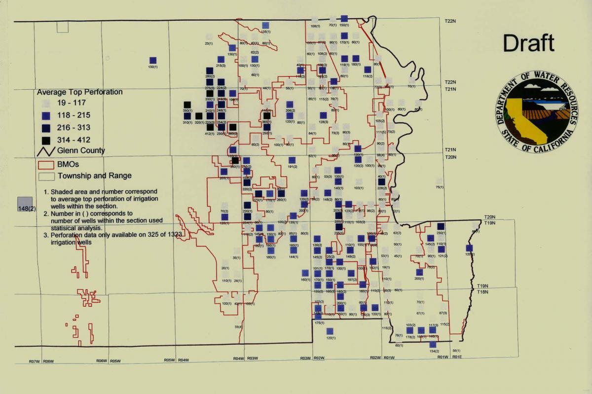
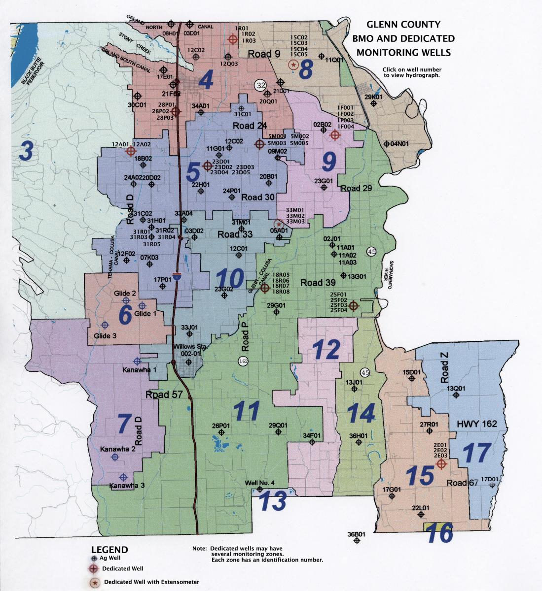
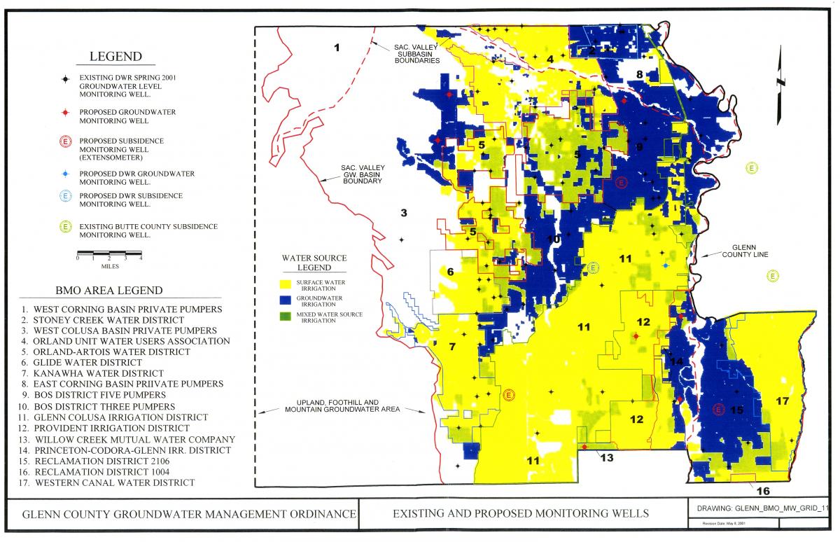
Dedicated Monitoring Wells
Updated:
| Attachment | Size |
|---|---|
| Dedicated Monitoring Wells (214.46 KB) | 214.46 KB |
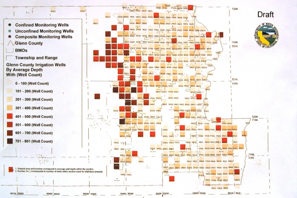
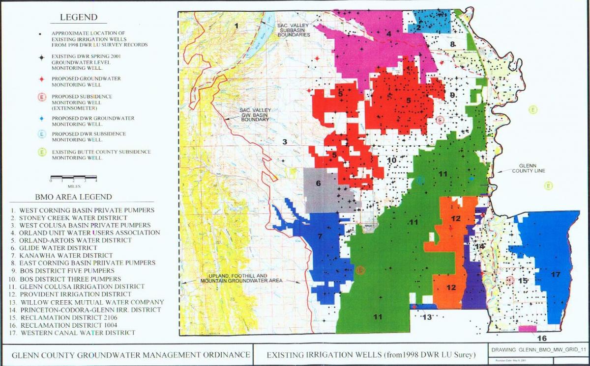
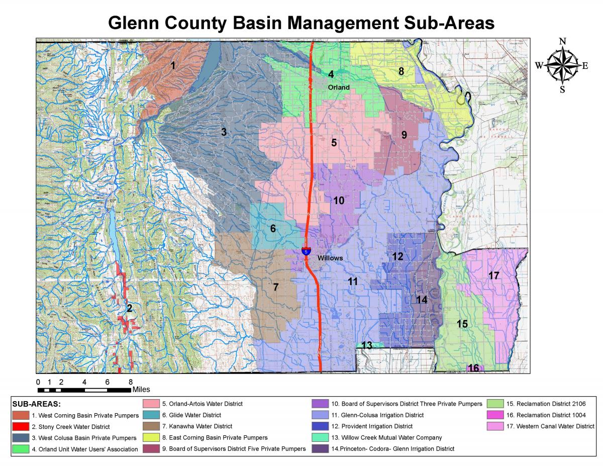
Glenn County BMO Sub-Areas
Updated:
| Attachment | Size |
|---|---|
| Glenn County BMO Sub-Areas (246.32 KB) | 246.32 KB |
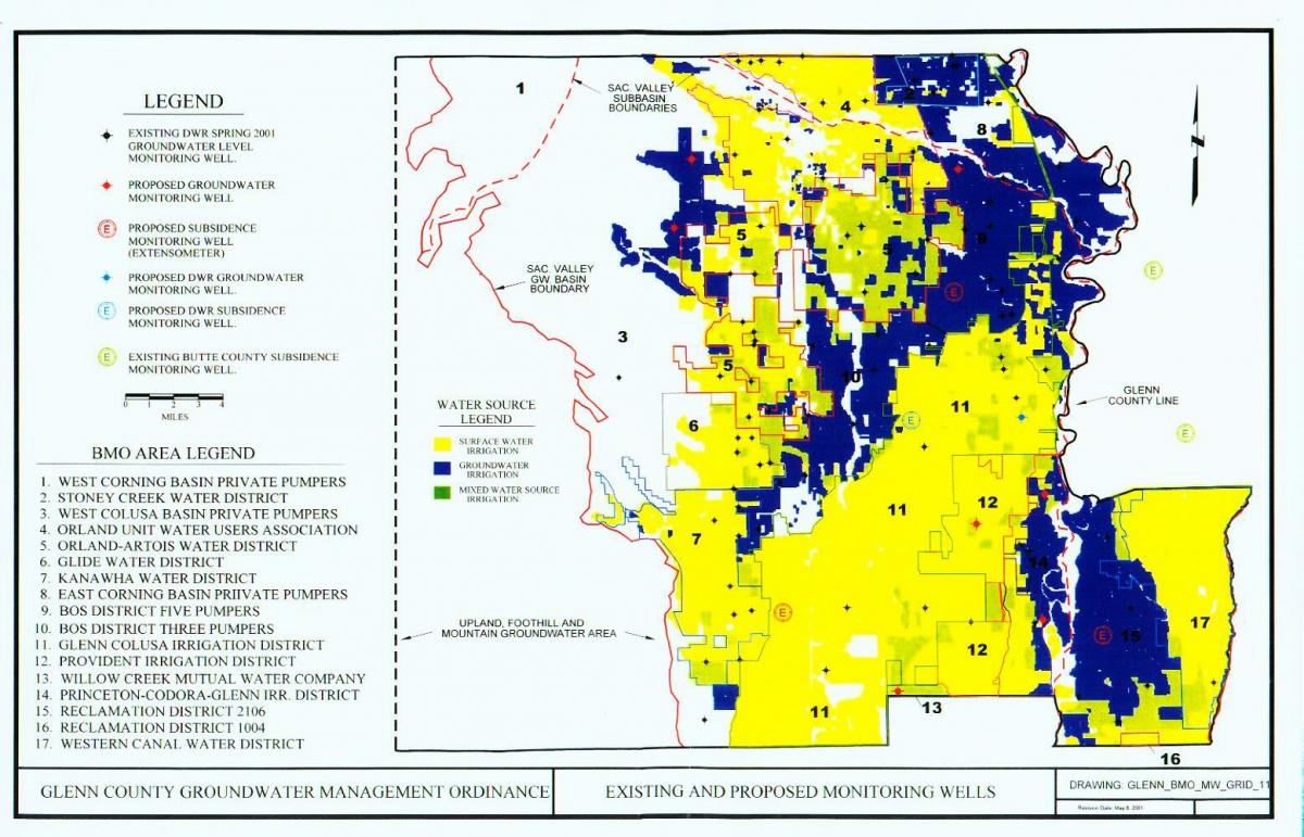
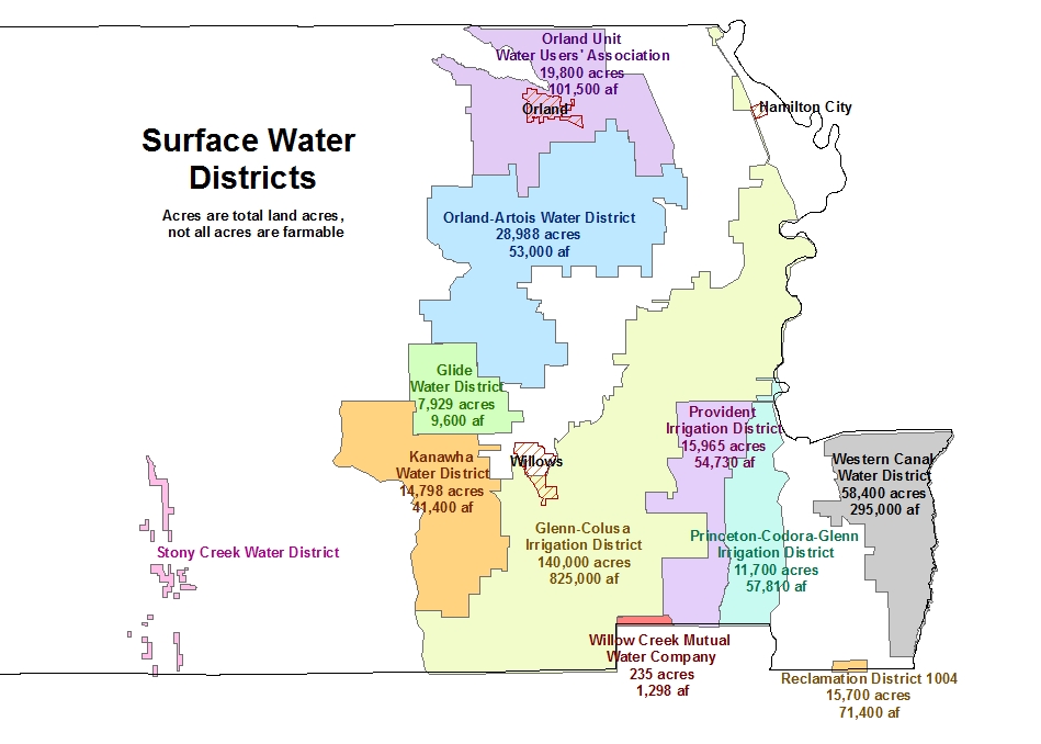
Map of Water Sources in Glenn County
Updated:
| Attachment | Size |
|---|---|
| Water Sources in Glenn County (164.7 KB) | 164.7 KB |
Orland Area Of Concern Map 2005
Updated:
| Attachment | Size |
|---|---|
| Orland Area Of Concern Map 2005 (113.07 KB) | 113.07 KB |
Underground Storage Tank - Site Map (Sample)
Updated:
| Attachment | Size |
|---|---|
| Underground Storage Tank - Site Map (Sample) (71 KB) | 71 KB |
Hazardous Materials Business Plan - Facility Map
Updated:
| Attachment | Size |
|---|---|
| Hazardous Materials Business Plan - Facility Map (1.04 MB) | 1.04 MB |
Willows Airport Master Plan Adopted August 19, 2008
Updated:
| Attachment | Size |
|---|---|
| WAMP - Title Page (42.83 KB) | 42.83 KB |
| WAMP - Table of Contents (89.87 KB) | 89.87 KB |
| WAMP - Background & Inventory (6.79 MB) | 6.79 MB |
| WAMP - Airport Role & Activity Forecasts (152.22 KB) | 152.22 KB |
| WAMP - Airfield Design (1.28 MB) | 1.28 MB |
| WAMP - Building Area Development (236.6 KB) | 236.6 KB |
| WAMP - Finance & Implementation (947.81 KB) | 947.81 KB |
| WAMP - Reference Documents (51.25 KB) | 51.25 KB |
| WAMP - Noise Model Calculation Data (70.63 KB) | 70.63 KB |
| WAMP - Glossary of Terms (144.1 KB) | 144.1 KB |
| WAMP - Airport Layout - 1 of 6 (Updated Oct. 2010) (1.59 MB) | 1.59 MB |
| WAMP - Building Area Layout - 2 of 6 (Updated Oct. 2010) (747.44 KB) | 747.44 KB |
| WAMP - Data Layout - 3 of 6 (Updated Oct. 2010) (841.95 KB) | 841.95 KB |
| WAMP - Airspace Layout - 4 of 6 (Updated Oct. 2010) (759.34 KB) | 759.34 KB |
| WAMP - Airspace Layout - 5 of 6 (Updated Oct. 2010) (451.33 KB) | 451.33 KB |
| WAMP - Property Map Layout - 6 of 6 (Updated Oct. 2010) (815.81 KB) | 815.81 KB |