KNOW YOUR ZONE GLENN COUNTY
Access the Interactive Know Your Zone Map
Know Your Zone Map
Access the Active Evacuation Status Zone Map During a Disaster
Active Evacuation Status Zone Map
The Active Evacuation Zone Map is only used when there is an active incident occurring that results in the need for Evacuation Warning or Order, or Shelter In Place Order.
Identify the Evacuation Zone for your home, work, and other important locations.
When you enter the map, accept the terms and conditions to proceed. Once on the map, use the magnifying glass symbol to search your address.
Know Your Zone Map Directions: After opening the link to the map. Click the box in the left corner to agree to the terms to open the map above and find your zone. Please use the Magnifying Glass - Search Icon to look up your address. 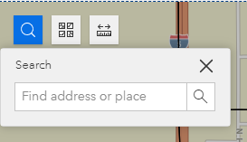
Once you have selected your address, the map will take you to that location. Once there, click on the map and a pop up box will appear with your Evacuation Zone Name and Number.
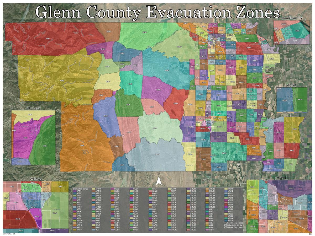
Glenn County Evacuation Zones
There are 165 evacuation zones that are organized in to 20 community areas. Each zone begins with a 3 letter community designation followed by the zone number. Example Orland community designation is ORL, followed by a zone number example ORL-1. For more information on this project, see the press release
A list of evacuation zones including zone border descriptions can be found in the Table below or in these document: Evacuation Zone Sortable Excel Table, Evacuation Zone Table PDF
Current Incident Evacuation Information
Current Incidents - None
Active Evacuation Status Zone Map - No active evacuations
Evacuation Zone and Current Status Table
The table below identifies the Zone, it's boundaries, and current Evacuation Status. If your Zone is under an Evacuation Warning or Order, it will be listed here in the right hand column.
| Area | Zone | From | North Boundary | South To Directions | South Boundary | From | West Boundary | East to Directions | East Boundary | Evacuation Status | |
| Afton | AFT 1 | From | County Road 67 | south to | County Road 69 | From | Sacramento River | east to | County Road Y | None | |
| Afton | AFT 2 | From | County Road 67 | south to | County Road 70 | From | County Road Y | east to | County Road Z | ||
| Afton | AFT 3 | From | County Road 67 | south to | Colusa-Glenn County Line | From | County Road Z | east to | Butte-Glenn County Line | ||
| Afton | AFT 4 | From | County Road 69 | south to | Colusa-Glenn County Line | From | Sacramento River | east to | County Road YY | ||
| Artois | ART 1 | From | County Road 25 | south to | County Road 30 | From | County Road C | east to | County Road D | ||
| Artois | ART 2 | From | County Road 25 | south to | County Road 28 | From | County Road D | east to | County Road F | ||
| Artois | ART 3 | From | County Road 25 | south to | County Road 28 | From | County Road F | east to | I-5 | ||
| Artois | ART 4 | From | County Road 25 | south to | County Road 27 | From | I-5 | east to | County Road M | ||
| Artois | ART 5 | From | County Road 25 | south to | County Road 27 | From | County Road M | east to | County Road P | ||
| Artois | ART 6 | From | County Road 25 | south to | County Road 30 | From | County Road P | east to | County Road S | ||
| Artois | ART 7 | From | County Road 25 | south to | County Road 30 | From | County Road S | east to | County Road V | ||
| Artois | ART 8 | From | County Road 28 | south to | County Road 33 | From | County Road D | east to | County Road F | ||
| Artois | ART 9 | From | County Road 28 | south to | County Road 31 | From | County Road F | east to | I-5 | ||
| Artois | ART 10 | From | County Road 27 | south to | County Road 31 | From | I-5 | east to | County Road M | ||
| Artois | ART 11 | From | County Road 27 | south to | County Road 30 | From | County Road M | east to | County Road P | ||
| Artois | ART 12 | From | County Road 31 | south to | County Road 33 | From | County Road F | east to | I-5 | ||
| Artois | ART 13 | From | County Road 30 | south to | County Road 33 | From | I-5 | east to | County Road M | ||
| Artois | ART 14 | From | County Road 30 | south to | County Road 33 | From | County Road M | east to | County Road P | ||
| Artois | ART 15 | From | County Road 30 | south to | County Road 33 | From | County Road P | east to | County Road S | ||
| Artois | ART 16 | From | County Road 30 | south to | County Road 34 | From | County Road S | east to | County Road V | ||
| Artois | ART 17 | From | County Road 33 | south to | County Road 35 | From | County Road D | east to | I-5 | ||
| Artois | ART 18 | From | County Road 33 | south to | County Road 35 | From | I-5 | east to | County Road 99W | ||
| Artois | ART 19 | From | County Road 33 | south to | County Road 35 | From | County Road 99W | east to | County Road P | ||
| Artois | ART 20 | From | County Road 33 | south to | County Road 39 | From | County Road P | east to | County Road R | ||
| Artois | ART 21 | From | County Road 35 | south to | County Road 39 | From | County Road D | east to | I-5 | ||
| Artois | ART 22 | From | County Road 35 | south to | County Road 39 | From | I-5 | east to | County Road 99W | ||
| Artois | ART 23 | From | County Road 35 | south to | County Road 39 | From | County Road 99W | east to | County Road P | ||
| Artois | ART 24 | From | County Road 39 | south to | County Road 45 | From | I-5 | east to | County Road 99W | ||
| Artois | ART 25 | From | County Road 39 | south to | County Road 45 | From | County Road 99W | east to | County Road P | ||
| Artois | ART 26 | From | County Road 39 | south to | County Road 45 | From | County Road P | east to | County Road R | ||
| Bayliss | BAY 1 | From | County Road 34 | south to | County Road 39 | From | County Road R | east to | County Road V | ||
| Bayliss | BAY 2 | From | County Road 34 | south to | County Road 39 | From | County Road V | east to | County Road X | ||
| Bayliss | BAY 3 | From | County Road 34 | south to | County Road 39 | From | County Road X | east to | SR 45 | ||
| Bayliss | BAY 4 | From | County Road 39 | south to | County Road 44 | From | County Road R | east to | County Road V | ||
| Bayliss | BAY 5 | From | County Road 39 | south to | County Road 44 | From | County Road V | east to | County Road X | ||
| Bayliss | BAY 6 | From | County Road 39 | south to | County Road 44 | From | County Road X | east to | Butte-Glenn County Line | ||
| Butte City | BUC 1 | From | Butte-Glenn County Line | south to | SR 162 | From | Sacramento River | east to | County Road Y | ||
| Butte City | BUC 2 | From | County Road 50 | south to | SR 162 | From | County Road Y | east to | County Road Z | ||
| Butte City | BUC 3 | From | Butte-Glenn County Line | south to | SR 162 | From | County Road Z | east to | Butte-Glenn County Line | ||
| Butte City | BUC 4 | From | SR 162 | south to | County Road 67 | From | Sacramento River | east to | County Road Y | ||
| Butte City | BUC 5 | From | SR 162 | south to | County Road 67 | From | County Road Y | east to | County Road Z | ||
| Butte City | BUC 6 | From | SR 162 | south to | County Road 67 | From | County Road Z | east to | Butte-Glenn County Line | ||
| Capay | CAP 1 | From | Tehama-Glenn County Line | South to | County Road 7 - Capay Ave | From | Sixth Ave | east to | Fourth Ave | ||
| Capay | CAP 2 | From | Tehama-Glenn County Line | South to | County Road 7 - Capay Ave | From | Fourth Ave | east to | Third Ave | ||
| Capay | CAP 3 | From | Tehama-Glenn County Line | South to | County Road 7 - Capay Ave | From | Third Ave | east to | Sacramento River | ||
| Capay | CAP 4 | From | County Road 7 | South to | County Road 9 - Wyo | From | Sixth Ave | east to | Fourth Ave | ||
| Capay | CAP 5 | From | County Road 7 | South to | County Road 9 - Wyo | From | Fourth Ave | east to | Third Ave | ||
| Capay | CAP6 | From | County Road 7 | South to | County Road 9 - Wyo | From | Third Ave | east to | Sacramento River | ||
| Chrome | CHM 1 | From | Burrows Gap/Heifer Camp Creek | south to | County Road 313 | From | USFS - Forest Boundary | east to | County Road 306 | ||
| Chrome | CHM 2 | From | Burrows Gap/County Road 200A | south to | County Road 314 | From | County Road 306 | east to | Stony Creek | ||
| Chrome | CHM 3 | From | County Road 313 | south to | Forest Highway 7 (FH7) | From | USFS - Forest Boundary | east to | County Road 306 | ||
| Clarks valley | CLV 1 | From | Intersection of County Road 302 and County Road 303 | south to | Intersection of County Road 303 and County Road 306 | From | County Road 306 | east to | County Road 303 | ||
| Codora | COD 1 | From | County Road 54 | south to | County Road 61 | From | Willow Creek | east to | SR 45 | ||
| Codora | COD 2 | From | County Road 54 | south to | SR 162 | From | SR 45 | east to | Sacramento River | ||
| Codora | COD 3 | From | County Road 61 | south to | County Road 66 | From | County Road V | east to | SR 45 | ||
| Codora | COD 4 | From | SR 162 | south to | Colusa-Glenn County Line | From | SR 45 | east to | Sacramento River | ||
| Codora | COD 5 | From | County Road 66 | south to | Colusa-Glenn County Line | From | County Road V | east to | SR 45 | ||
| Elk Creek | ELK 1 | From | Forest Highway 7 (FH7) | south to | County Road 309 | From | USFS - Forest Boundary | east to | County Road 306 | ||
| Elk Creek | ELK 2 | From | Forest Highway 7 (FH7) intersection with County Road 306 | south to | SR 162 | From | County Road 306 | east to | Intersection of County Road 303/SR 162 | ||
| Elk Creek | ELK 3 | From | County Road 309 | south to | County Road 308 | From | USFS - Forest Boundary | east to | west side of Elk Creek town limits | ||
| Elk Creek | ELK 4 | From | County Road 309 and north of High School | south to | County Road 308 | From | west side of Elk Creek town limits | east to | County Road 306 | ||
| Elk Creek | ELK 5 | From | County Road 308 | south to | Intersection of County Road 410 and County Road 306 | From | USFS - Forest Boundary | east to | County Road 306 | ||
| Fruto | FRT 1 | From | SR 162 | south to | Intersection of County Road 302 and County Road 303 | From | County Road 306 | east to | County Road 303 | ||
| Fruto | FRT 2 | From | SR 162 | south to | County Road 302 | From | County Road 303 | east to | Intersection of County Road 302 and SR 162 | ||
| Glenn | GLN 1 | From | County Road 44 | south to | SR 162 | From | SR 45 | east to | Butte-Glenn County Line | ||
| Glenn | GLN 2 | From | County Road 44 | south to | SR 162 | From | County Road X | east to | SR 45 | ||
| Glenn | GLN 3 | From | County Road 44 | south to | County Road 48 | From | SR 45 | east to | Butte-Glenn County Line | ||
| Glenn | GLN 4 | From | SR 162 | south to | County Road 59 | From | County road V | east to | County Road WW | ||
| Glenn | GLN 5 | From | SR 162 | south to | County Road 59 | From | County Road WW | east to | SR 45 | ||
| Glenn | GLN 6 | From | County Road 48 | south to | County Road 54 | From | SR 45 | east to | Sacramento River | ||
| Grindstone | GRD 1 | From | Stony Creek (south of Road 305) | south to | Forest Highway 7 (FH7) | From | County Road 306 | east to | through Grindstone Rancheria to boundary | ||
| Grindstone | GRD 2 | From | County Road 314 | south to | Stony Creek (south of Rd 305) | From | County Road 306 | east to | Stony Creek (where it bends north) | ||
| Hamilton City | HAM 1 | From | County Road 9 - Wyo | South to | SR 32 | From | 6th Ave | east to | Canal Street (SR 45) | ||
| Hamilton City | HAM 2 | From | County Road 9 - Wyo | South to | SR 32 | From | Canal St (SR 45) | east to | Sacramento River | ||
| Hamilton City | HAM 3 | From | SR 32 | South to | County Road 24 | From | County Road S | east to | SR 45 | ||
| Hamilton City | HAM 4 | From | SR 32 | South to | 1st Street | From | Canal Street (SR 45) | east to | Railroad Tracks | ||
| Hamilton City | HAM 5 | From | SR 32 | South to | 1st Street | From | Railroad Tracks | east to | Sacramento River | ||
| Hamilton City | HAM 6 | From | 1st St | South to | County Road 23 | From | SR 45 | east to | Butte-Glenn County Line | ||
| Hamilton City | HAM 7 | From | County Road 24 | South to | County Road 27 | From | County Road V | east to | SR 45 | ||
| Hamilton City | HAM 8 | From | County Road 23 | south to | County Road 26 | From | SR 45 | east to | Butte-Glenn County Line | ||
| Indian Valley | INV 1 | From | Intersection of County Road 410 and County Road 306 | south to | Colusa-Glenn County Line | From | USFS - Forest Boundary | east to | County Road 306 | ||
| Indian Valley | INV 2 | From | County Road 400 | south to | Colusa-Glenn County Line | From | County Road 401 | east to | Tehama-Colusa Canal | ||
| Indian Valley | INV 3 | From | County Road 303 | south to | Colusa-Glenn County Line | From | County Road 306 | east to | County Road 401 | ||
| Kanawha | KAW 1 | From | County Road 26 | south to | County Road 35 | From | County Road 305 | east to | County Road D | ||
| Kanawha | KAW 2 | From | Tehama-Cousa Canal | south to | County Road 35 | From | Tehama-Colusa Canal | east to | County Road D | ||
| Kanawha | KAW 3 | From | County Road 35 | south to | SR 162 | From | County Road 302 intersection with SR 162 | east to | County Road 303 intersection with SR 162 | ||
| Kanawha | KAW 4 | From | County Road 35 | south to | SR 162 | From | County Road 303 intersection with SR 162 | east to | Tehama-Colusa Canal | ||
| Kanawha | KAW 5 | From | County Road 35 | south to | County Road 48 | From | Tehama-Colusa Canal | east to | County Road D | ||
| Kanawha | KAW 6 | From | County Road 60 | south to | Colusa-Glenn County Line | From | Tehama-Colusa Canal | east to | County Road D | ||
| Kanawha | KAW 7 | From | County Road 302 | south to | County Road 400 | From | County Road 303 | east to | Tehama-Colusa Canal | ||
| Kanawha | KAW 8 | From | County Road 48 | south to | County Road 60 | From | Tehama-Colusa Canal | east to | County Road D | ||
| Kanawha | KAW 9 | From | County Road 60 | south to | Colusa-Glenn County Line | From | Tehama-Colusa Canal | east to | County Road D | ||
| Newville | NEW 1 | From | Tehama-Glenn County Line | south to | Burrows Gap/Heifer Camp Creek | From | USFS - Forest Boundary | east to | County Road 306 | ||
| Newville | NEW 2 | From | Tehama-Glenn County Line | south to | Burrows Gap/Heifer Camp Creek | From | County Road 306 | east to | County Road 200A | ||
| Ord Bend | ORD 1 | From | County Road 27 | south to | County Road 29 | From |
| east to | SR 45 | ||
| Ord Bend | ORD 2 | From | County Road 26 | south to | County Road 29 | From | SR 45 | east to | Butte-Glenn County Line | ||
| Ord Bend | ORD 3 | From | County Road 29 | south to | County Road 32 | From | County Road V | east to | SR 45 | ||
| Ord Bend | ORD 4 | From | County Road 29 | south to | County Road 32 - Ord Ferry Rd | From | SR 45 | east to | Butte-Glenn County Line | ||
| Ord Bend | ORD 5 | From | County Road 32 | south to | County Road 34 | From | County Road V | east to | SR 45 | ||
| Ord Bend | ORD 6 | From | County Road 32 - Ord Ferry Rd | south to | County Road 39 | From | SR 45 | east to | Butte-Glenn County Line | ||
| Orland | ORL 1 | From | Tehama-Glenn County Line | south to | County Road 200 | From | County Road 200 | east to | County Road DD | ||
| Orland | ORL 2 | From | Tehama-Glenn County Line | south to | Stony Creek | From | Stony Creek/County Line | east to | I-5 | ||
| Orland | ORL 3 | From | Tehama-Glenn County Line | south to | County Road 6 | From | I-5 | east to | County Road MM | ||
| Orland | ORL 4 | From | Tehama-Glenn County Line | south to | County Road 6 | From | County Road MM | east to | County Road P | ||
| Orland | ORL 5 | From | Tehama-Glenn County Line | south to | County Road 9 | From | County Road P | east to | 6th Ave (County Rd 202) | ||
| Orland | ORL 6 | From | County Road 6 | south to | County Road 9 - Wyo | From | I-5 | east to | County Road MM | ||
| Orland | ORL 7 | From | County Road 6 | south to | County Road 9 - Wyo | From | County Road MM | east to | County Road P | ||
| Orland | ORL 8 | From | Stony Creek | south to | County Road 200 | From | County Road DD | east to | I-5 | ||
| Orland | ORL 9 | From | Stony Creek | south to | SR 32 - Newville Road | From | I-5 | east to | CR 99W | ||
| Orland | ORL 10 | From | Stony Creek | south to | Shasta Street | From | County Road 99W | east to | East Street | ||
| Orland | ORL 11 | From | County Road 9 | South to | Stony Creek | From | County Road 99W | east to | County Road P | ||
| Orland | ORL 12 | From | County Road 9 | South to | Stony Creek | From | County Road P | east to | County Road 202 (6th Ave.) | ||
| Orland | ORL 13 | From | Stony Creek | south to | SR 32 - Walker Street | From | East street | east to | County Road MM 1/2 | ||
| Orland | ORL 14 | From | Stony Creek | south to | SR 32 - Walker Street | From | Papst Ave | east to | County Road N | ||
| Orland | ORL 15 | From | Stony Creek | south to | SR 32 - Walker Street | From | County Road N | east to | County Road P | ||
| Orland | ORL 16 | From | Stony Creek | south to | SR 32 - Walker Street | From | County Road P | east to | County Road S | ||
| Orland | ORL 17 | From | Shasta Street | south to | SR 32 - Walker Street | From | 6th Street (County Rd 99W) | east to | East Street | ||
| Orland | ORL 18 | From | E. Shasta Street | south to | SR 32 - Walker Street | From | East street | east to | Papst Ave | ||
| Orland | ORL 19 | From | County Road 200 | south to | County Road 14 | From | County Road C | east to | County Road E | ||
| Orland | ORL 20 | From | County Road 200 | south to | County Road 17 | From | County Road E | east to | I-5 | ||
| Orland | ORL 21 | From | SR 32 - Walker Street | south to | South Street | From | I-5 | east to | 6th Street/County Road 99W | ||
| Orland | ORL 22 | From | SR 32 - Walker Street | south to | South Street | From | 6th Street (County Rd 99W) | east to | East Street | ||
| Orland | ORL 23 | From | SR 32 - Walker Street | south to | South Street | From | East street | east to | Papst Ave | ||
| Orland | ORL 24 | From | SR 32 - Walker Street | south to | County Road 200 | From | Papst Ave | east to | County Road N | ||
| Orland | ORL 25 | From | SR 32 - Walker Street | south to | County Road 200 | From | County Road N | east to | County Road P | ||
| Orland | ORL 26 | From | SR 32 - Walker Street | south to | County Road 20 | From | County Road P | east to | County Road S | ||
| Orland | ORL 27 | From | County Road 200 | south to | County Road 26 | From | County Road 200A | east to | County Road F | ||
| Orland | ORL 28 | From | County Road 16 | south to | County Road 20 | From | County Road E | east to | I-5 | ||
| Orland | ORL 29 | From | South Street | south to | County Road 20 | From | I-5 | east to | County Road 99W | ||
| Orland | ORL 30 | From | South Street | south to | County Road 20 | From | County Road 99W | east to | County Road M | ||
| Orland | ORL 31 | From | County Road 200 | south to | County Road 24 | From | County Road M | east to | County Road P | ||
| Orland | ORL 32 | From | County Road 20 | south to | County Road 24 | From | County Road P | east to | County Road S | ||
| Orland | ORL 33 | From | County Road 20 | south to | County Road 25 | From | County Road F | east to | I-5 | ||
| Orland | ORL 34 | From | County Road 20 | south to | County Road 24 | From | I-5 | east to | County Road M | ||
| Orland | ORL35 | From | County Road 24 | south to | County Road 25 | From | I-5 | east to | County Road M | ||
| Orland | ORL 36 | From | County Road 24 | south to | County Road 25 | From | County Road M | east to | County Road P | ||
| Orland | ORL 37 | From | County Road 24 | south to | County Road 25 | From | County Road P | east to | County Road S | ||
| Orland | ORL 38 | From | County Road 24 | south to | County Road 25 | From | County Road S | east to | County Road V | ||
| USFS - Mendo | FSM 1 | From | Tehama-Glenn County Line | south to | Forest Highway 7 (FH7) | From | Mendocino-Glenn County Line | east to | USFS - Forest Boundary | ||
| USFS - Mendo | FSM 2 | From | Forest Highway 7 (FH7) | south to | County Road 308 | From | Mendocino-Glenn County Line | east to | USFS - Forest Boundary | ||
| USFS - Mendo | FSM 3 | From | County Road 308 | south to | Colusa-Glenn County Line | From | Mendocino-Glenn County Line | east to | USFS - Forest Boundary | ||
| Willows | WIL 1 | From | County Road 45 | south to | County Road 48 | From | I-5 | east to | County Road 99W | ||
| Willows | WIL 2 | From | County Road 45 | south to | County Road 48 | From | County Road 99W | east to | County Road P | ||
| Willows | WIL 3 | From | County Road 45 | south to | County Road 48 | From | County Road P | east to | County Road S | ||
| Willows | WIL 4 | From | County Road 44 | south to | SR 162 | From | County Road S | east to | County Road V | ||
| Willows | WIL 5 | From | County Road 48 | south to | SR 162 | From | County Road D | east to | I-5 | ||
| Willows | WIL 6 | From | County Road 48 | south to | Railroad Tracks | From | I-5 | east to | County Road 99W | ||
| Willows | WIL 7 | From | County Road 48 | south to | SR 162 | From | County Road 99W | east to | Glenn-Colusa Canal | ||
| Willows | WIL 8 | From | County Road 48 | south to | SR 162 | From | Glenn-Colusa Canal | east to | County Road P | ||
| Willows | WIL 9 | From | Railroad Tracks | south to | SR 162/Wood Street | From | I-5 | east to | County Road 99W | ||
| Willows | WIL 10 | From | SR 162 | south to | County Road 53 | From | County Road D | east to | County Road F | ||
| Willows | WIL 11 | From | SR 162 | south to | County Road 53 | From | County Road F | east to | I-5 | ||
| Willows | WIL 12 | From | SR 162/Wood Street | south to | Laurel Street | From | I-5 | east to | County Road 99W/Tehama Street | ||
| Willows | WIL 13 | From | SR 162/Wood Street | south to | Glenn-Colusa Canal | From | County Road 99W/Tehama Street | east to | Glenn-Colusa Canal | ||
| Willows | WIL 14 | From | Laurel Street | south to | Glenn-Colusa Canal | From | I-5 | east to | County Road 99W/Tehama Street | ||
| Willows | WIL 15 | From | SR 162 | south to | County Road 57 | From | Glenn-Colusa Canal | east to | County Road P | ||
| Willows | WIL 16 | From | SR 162 | south to | County Road 57 | From | County Road P | east to | County Road S | ||
| Willows | WIL 17 | From | SR 162 | south to | County Road 57 | From | County Road S | east to | County Road V | ||
| Willows | WIL 18 | From | County Road 53 | south to | County Road 57 | From | County Road D | east to | I-5 | ||
| Willows | WIL 19 | From | Glenn-Colusa Canal | south to | County Road 57 | From | I-5 | east to | County Road 99W | ||
| Willows | WIL 20 | From | County Road 57 | south to | County Road 62 | From | County Road D | east to | I-5 | ||
| Willows | WIL 21 | From | County Road 57 | south to | County Road 60 | From | I-5 | east to | County Road P | ||
| Willows | WIL 22 | From | County Road 57 | south to | County Road 60 | From | County Road P | east to | Willow Creek | ||
| Willows | WIL 23 | From | County Road 62 | south to | Colusa-Glenn County Line | From | County Road D | east to | I-5 | ||
| Willows | WIL 24 | From | County Road 60 | south to | County Road 68 | From | I-5 | east to | County Road V | ||
| Willows | WIL 25 | From | County Road 68 | south to | Colusa-Glenn County Line | From | I-5 | east to | Colusa-Glenn County Line |
EVACUATION DEFINITIONS
EVACUATION WARNING
An Evacuation Warning is issued when conditions exist which indicate an Evacuation Order may be given in the near future. The threat to lives is not yet imminent, but due to the potential for rapidly changing conditions to develop into a serious threat, the public is advised to prepare for the issue of an Evacuation Order.
- Residents are advised to leave the area.
- Those with special evacuation needs, such as care facilities or those with special transportation needs are particularly encouraged to leave as soon as possible after the Evacuation Warning is issued.
- Businesses are advised to take whatever precautions they deem necessary for protecting equipment and/or inventory.
- Access to the area under an Evacuation Warning is unrestricted.
Evacuation Warnings may also be issued when a Mandatory Evacuation order has been lifted in an area but the conditions in the area remain subject to rapid change and could again become serious.
EVACUATION ORDER
An Evacuation Order is issued where there is an immediate threat to life in a defined area. The danger is imminent. An Evacuation Order is given pursuant to the Penal Code Section 409.5, and is lawfully enforceable.
- All non-essential persons are ordered to immediately leave the area via the described evacuation routes.
- Persons are legally required to leave the affected area due to threat to life.
An Evacuation Order requires the immediate movement of people out of an affected area due to an imminent threat to life. Choosing to stay could result in loss of life. Staying may also impede the work of emergency personnel. Due to the changing nature of the emergency, an Evacuation Order may be the only alert that people receive in the affected area (s).
Page last updated 9/29/2022
Related Files
| Attachment | Size |
|---|---|
| Evacuation Zone Table 9-29-22 (266.86 KB) | 266.86 KB |
| Sortable Evacuation Zone Table 9-29-22 (26.22 KB) | 26.22 KB |